












Great Nicobar Island port: India’s strategic foot in a global gateway

By Capt Naveen S Singhal & Capt MM Saggi
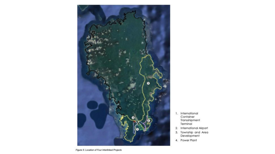
In September 2024 the government of India notified the International Container Transshipment Port (ICTP) as India’s 13th major port. The strategic port is part of the Rs 72,000 crore Great Nicobar Island Development Project, spread over three phases over 30 years. The first phase investment in port infrastructure of about US$ 2.1 billion (Rs 18,000 crore) likely to be completed by 2028. The second phase and third phases are expected 2040 and 2058 which includes international civil amenities and tourist attractions.
Great Nicobar Island, one of 572 islands on the Andaman and Nicobar island chain, has a population of about 8000 people. Its 1044- square- kilometre area is 35 per cent more than the territory of Singapore. Indira Point on the island is India’s southernmost territory and located at about 6.6 degrees (N) latitude.
The strategic project in Great Nicobar Island’s Galathea Bay will mark India’s arrival at the mouth of the world’s most important shipping lane— the Malacca Strait, a narrow sea passage with the world’s highest annual shipping traffic density. Approximately 100,000 ships pass through here annually. India is poised to emerge as a key regional maritime power and a joint guardian of this important global trade route that stretches about 575 nautical miles from Singapore to Sabang, a city on Weh Island, in the northern part of the Malacca Strait.
Nicobar is located 40 nautical miles north-west of Sabang, located just off the northern tip of Sumatra. Sabang was occupied by the Imperial Japanese Navy during the Second World War. IJN warships, submarines and aircraft used the strategically vital base controlling the entrance to the Malacca Straits. The island continues to be important and relevant for ensuring regional safety. In 2024, India and Indonesia completed a feasibility study for the joint development of Sabang port.
The Malacca Strait Patrol
The Malacca Strait Patrol (MSP), a cooperative maritime security framework involving warships and maritime patrol aircraft from Indonesia, Singapore and Malaysia was launched in 2006 while Thailand joined in 2008. It consists of coordinated sea patrols, combined maritime air patrols and an intelligence Exchange Group (IEG) that shares information and coordinates responses. The MSP’s prime objective is to secure borders from piracy, terrorism, armed robbery, ensure freedom of navigation and enhance surveillance. India is kept out of the MSP because it is considered a non-littoral state with no coastline near the Malacca Strait. This exclusion is strange because Galathea Bay is just 90 nautical miles away from Sabang. Thailand’s inclusion into the MSP was because it is 60 nautical miles away from the centre of the Malacca Strait.
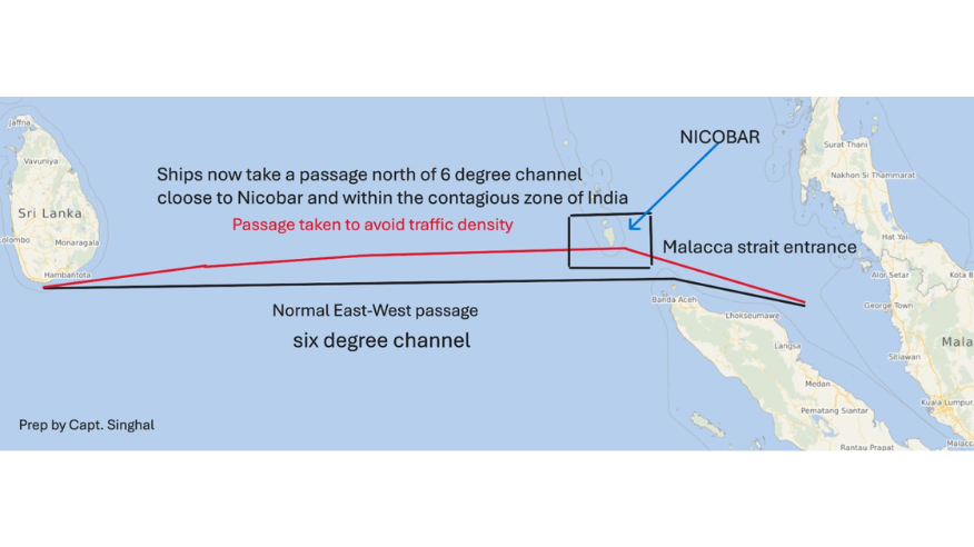
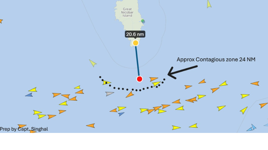
Moreover, an increase in shipping density has altered the traditional East-West passage normally used by vessels entering or exiting the Malacca Strait. Vessels now choose a passage which is many miles north of the usual East-West passage or the ‘Six Degree Channel’. This traffic thus breaches India's contigious zone (24 nautical miles from Galathea Bay) (see graphic).
India has other compelling reasons for joining the Malacca Strait Patrol (MSP). It has the world’s sixth largest navy, a geographic advantage, non-aggressive capabilities and a commitment to regional security in the Indo-Pacific,
The issue of India’s inclusion into the MSP was raised during talks between Prime Minister Modi and Singapore’s Lawrence Wong in New Delhi on September 4. Singapore backed India’s interest in joining the MSP, but the green signal still needs to be given by Indonesia and Malaysia. There are other reasons why India should be concerned with potential security concerns in the region. Activities such as STS (Ship to Ship transfer) operations, presence of fishing vessels in the high seas in the Malacca Strait and adjoining Nicobar region, are potential security concerns for the region.
India’s NAIS (National Automatic Identification System) can also help in tracking the distress vessel and in SAR (Search and Rescue) operations. The NAIS also has the capability to create a virtual geo fencing and monitor breaches by fishing vessels violating international fishing boundaries. It has a robust maritime domain awareness (MDA) strategy centred around the National Maritime Domain Awareness (NMDA) project to enhance maritime and coastal security through a unified operational picture. This data is fused into a single network located at the recently-commissioned INS Aravali in Gurugram, New Delhi NCR.
More importantly, India is concerned by the safety of the contiguous zone, which extends to 24 nautical miles (NM) from the coast line. This zone gives a nation the right to exercise control and to prevent and punish infringements of its customs, fiscal, immigration, and sanitary laws providing the coastal state (India) with jurisdiction over the ocean's surface and floor, (minus air and space) to protect its national interests. The contiguous zone, is akin to the lobby in front of your apartment door. The lobby may not belong to the apartment owner, but the presence of this intruder in the space could be a cause of concern to the house owner. India’s entry into the Malacca Strait Patrol should thus be an automatic choice given its high stakes in the region.
Captain Naveen Singhal and Captain MM Saggi
Captain Naveen Singhal is a Singapore-based Shipping and Marine consultant.
Captain MM Saggi is former Nautical Advisor to the Government of India.



Comments